Over the past year, this space has been quieter than I intended but not for lack of work.
In that time, the scope and complexity of my work shifted pretty significantly. I focused on delivering several larger efforts, including three major projects that required more integrated analysis, expanded use of programmatic workflows, and closer coordination across disciplines. The work pushed me to deepen my technical approach while also thinking more critically about how analyses are structured and applied in practice. That shift led to new opportunities, a promotion, and changed how I think about the role of GIS and spatial science in real-world work.
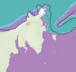
This color-adjusted near-infrared (NIR) image came out of walking through a workflow concept with a colleague. While only developed for those demonstration purposes, it ended up adding useful context to my own understanding of channel structures at river/ocean intersections during flood modeling.

Source: National Agriculture Imagery Program;
color adjustment by Michelle Toner
The tradeoff was that I stopped documenting as I went.
This update is a reset.
Over the coming weeks, I’ll be sharing a series of project write-ups covering:
- A statewide coastal vulnerability and prioritization analysis for Washington State, modeling multiple sea level rise, tidal, and storm scenarios to assess transportation risk. While the majority of my work has been done, as of this post the last stages are in review and awaiting publish by the State (anticipated in the Fall of 2026)
- A spatial analysis of proposed forestry buffer rules, modeling temperature and water quality impacts across non-fish streams in Western Washington
- A nationally funded research project developing a wildfire vulnerability approach for rail infrastructure, tested in California and intended for use across all states.
These projects reflect a shift toward work where GIS analysis is central to the outcome, not just something supporting other pieces of the project.
Going forward, I’ll be updating this space more selectively, focusing on work and ideas that are worth stepping back to examine. That includes:
- what it takes to keep up with rapidly expanding skill sets
- highlights from project work when there’s something interesting to unpack—focusing on approach and insight rather than step-by-step methods
- how GIS roles are evolving across organizations
- how work is actually structured and delivered in practice
The coastal vulnerability analysis project is now live here: